کارلاشتات آم ماین
کارلاشتات آم ماین | |
|---|---|
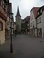
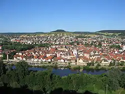 Clearly discernible, the Old Town and the new building area at the Saupurzel in the background | |
 نشان | |
 کارلاشتات آم ماین | |
موقعیت کارلاشتات آم ماین در منطقه Main-Spessart 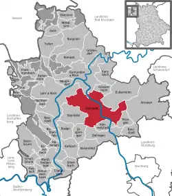 | |
| مختصات: ۴۹°۵۷′۳۷″ شمالی ۹°۴۶′۲۰″ شرقی | |
| کشور | آلمان |
| ایالت | بایرن |
| منطقه اداری | Unterfranken |
| ناحیه | Main-Spessart |
| تقسیمات | 9 روستاe |
| مدیریت | |
| • شهردار | Paul Kruck (Die Freien Wähler) |
| مساحت | |
| • کل | ۹۸٫۱۱ کیلومتر مربع (۳۸ مایل مربع) |
| بلندی | ۱۶۳ متر (۵۳۵ پا) |
| جمعیت (2013-12-31)[1] | |
| • کل | ۱۴٬۸۱۰ |
| • تراکم | ۱۵۰/کیلومتر مربع (۳۹۰/مایل مربع) |
| منطقه زمانی | |
| کدهای پستی | 97753 |
| کدهای شمارهگیری | 09353, 09359 (Rohrbach) |
| پلاک خودرو | MSP |
| وبگاه | |
جستارهای وابسته
منابع
- ویکیپدیای انگلیسی
- "Fortschreibung des Bevölkerungsstandes". Bayerisches Landesamt für Statistik und Datenverarbeitung (به German). 31 December 2013.
This article is issued from Wikipedia. The text is licensed under Creative Commons - Attribution - Sharealike. Additional terms may apply for the media files.