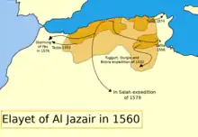
الجزایر عثمانی
الجزایر عثمانی[5] (Ottoman Algeria) یک دولت دست نشانده امپراتوری عثمانی[6] در شمال آفریقا بود که از ۱۵۱۶ تا ۱۸۳۰ و تا پیش از اشغال توسط فرانسه ادامه داشت. این منطقه بین سلطنت تونس در شرق و سلطنت مراکش در غرب (و داراییهای اسپانیا و پرتغال در آفریقای شمالی) واقع شده بود. در ابتدا مرزهای خود را از قاله در شرق تا ترارا در غرب و از الجزیره تا بسکره گسترش داد،[7] و سپس به مرزهای شرقی و غربی فعلی الجزایر محدود شد.[8] این کشور توسط فرمانداران منصوب شده توسط سلطان عثمانی (۱۵۱۸–۱۶۵۹)، حاکمان منصوب شده توسط فرماندهان نظامی اوجاک الجزایر (۱۶۵۹–۱۷۱۰) و سپس سلاطین منتخب دیوان الجزایر اداره میشد.
ایالت الجزایر | |||||||||||||||
|---|---|---|---|---|---|---|---|---|---|---|---|---|---|---|---|
| ۱۵۱۶–۱۸۳۰ | |||||||||||||||
 Flag[3]
 نشان ملی
| |||||||||||||||
.png.webp) نقشه ایالت الجزایر 1609 | |||||||||||||||
| وضعیت | Ottoman Vassal | ||||||||||||||
| پایتخت | الجزیره | ||||||||||||||
| زبان(های) رایج | عربی (رسمی، دولت، دینی، ادبی), زبانهای بربری , ترکی عثمانی (نخبگان، دیپلماتیک) | ||||||||||||||
| دین(ها) | اسلام (مالکی و حنفی), یهودیت | ||||||||||||||
| حکومت | Beylerbeylik (1518-1590) then Eyalet (1590-1830) of the Ottoman Empire | ||||||||||||||
| دایی (عنوان) | |||||||||||||||
• 1516-1518 | عروج رئیس | ||||||||||||||
• 1818-1830 | Hussein Dey | ||||||||||||||
| تاریخ | |||||||||||||||
• بنیانگذاری | ۱۵۱۶ | ||||||||||||||
• Invasion of Algiers in 1830 | ۱۸۳۰ | ||||||||||||||
| جمعیت | |||||||||||||||
• 1808 | 3,000,000 | ||||||||||||||
| |||||||||||||||
| امروز بخشی از | |||||||||||||||


تاریخ
در اوایل قرن شانزدهم میلادی، بسیاری از مسلمانان و یهودیان اخراج شده از اسپانیا در الجزایر پناهنده شدند. برخی از ساکنان الجزیره حملات دزدی دریایی به تجارت دریایی اسپانیا را آغاز کردند و در پاسخ اسپانیا در سال ۱۵۱۴ جزیره دریایی پونون در خلیج الجزیره را اشغال کرد. امیر الجزایر برای بیرون راندن اسپانیاییها از پونون به دو فرمانده ترک عثمانی متوسل شد و یکی از آنان به نام بارباروس خیرالدین پاشا الجزیره را تصرف کرد و اسپانیاییها را در سال ۱۵۲۹ بیرون راند. الجزایر تحت اختیار امپراتوری عثمانی قرار گرفت، اگرچه در عمل تا حد زیادی مستقل باقی ماند.[6]
جستارهای وابسته
منابع
- Gabor Agoston; Bruce Alan Masters (2009-01-01). Encyclopedia of the Ottoman Empire. Infobase Publishing. p. 33. ISBN 978-1-4381-1025-7. Retrieved 2013-02-25.
- Gabor Agoston; Bruce Alan Masters (2009-01-01). Encyclopedia of the Ottoman Empire. Infobase Publishing. p. 33. ISBN 978-1-4381-1025-7. Retrieved 2013-02-25.
- The red-and-yellow-striped banner flew over the city of Algiers in 1776 according to an article in The Flag Bulletin, Volume 25 (1986), p. 166. F. C. Leiner, The End of Barbary Terror: America's 1815 War Against the Pirates of North Africa (Oxford University Press, 2006), p. 7, describes a green flag with white crescent and stars being raised on Algerian pirate vessels in 1812. According to Tarek Kahlaoui, Creating the Mediterranean: Maps and the Islamic Imagination (Brill, 2018), p. 216, the city of Algiers is represented by a flag of red, yellow and green horizontal stripes in an Ottoman atlas of 1551. According to an 1849 engraving by Gustav Feldweg, the former Algerian flag was an arm holding a sword on a red field and the flag of the Algerian corsairs was a skull and crossbones on the same field. See also Historical flags of Algeria.
- Gabor Agoston; Bruce Alan Masters (2009-01-01). Encyclopedia of the Ottoman Empire. Infobase Publishing. p. 33. ISBN 978-1-4381-1025-7. Retrieved 2013-02-25.
- The Oxford Handbook of Contemporary Middle-Eastern and North African History p131.
- "Algiers | History & Geography". Encyclopedia Britannica. p. and in response Spain in 1514 fortified the offshore island of Peñon in the Bay of Algiers. The emir of Algiers appealed to two Ottoman Turkish corsairs to expel the Spaniards from the Peñon, and one of the corsairs, Barbarossa (Khayr al-Dīn), seized Algiers and expelled the Spaniards in 1529. Algiers was placed under the authority of the Ottoman sultan, although in practice it remained largely autonomous. Retrieved 2021-02-04.
- Collective coordinated by Hassan Ramaoun, L'Algérie: histoire, société et culture, Casbah Editions, 2000, 351 p. (ISBN 9961-64-189-2), p. 27.
- Hélène Blais. "La longue histoire de la délimitation des frontières de l'Algérie", in Abderrahmane Bouchène, Jean-Pierre Peyroulou, Ouanassa Siari Tengour and Sylvie Thénault, Histoire de l'Algérie à la période coloniale: 1830-1962, Éditions La Découverte [fr] et Éditions Barzakh, 2012 (ISBN 9782707173263), p. 110-113.