جزیره بارو (استرالیای غربی)
جزیره بارو (استرالیای غربی) (به انگلیسی: Barrow Island (Western Australia)) یک جزیره در استرالیا است که در استرالیای غربی واقع شدهاست.[3]
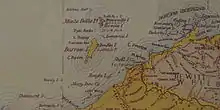 Barrow Island from an 1897 map, showing the استرالیاn mainland on the bottom right (south-east) and the Montebello Islands to the north | |
| جغرافیا | |
|---|---|
| مکان | اقیانوس هند، off the پیلبارا coast of استرالیای غربی |
| مختصات | ۲۰٫۷۹۸°جنوبی ۱۱۵٫۴۰۶°شرقی[1] |
| مساحت | ۲۰۲ کیلومتر مربع (۷۸ مایل مربع) |
| طول | ۲۷ کیلومتر (۱۶٫۸ مایل) |
| عرض | ۱۱٫۵ کیلومتر (۷٫۱۵ مایل) |
| کرانهها | ۷۲ کیلومتر (۴۴٫۷ مایل) |
| کشور | |
Australia | |
| ایالتها و ناحیههای استرالیا | استرالیای غربی |
جستارهای وابسته
منابع
- "Barrow Island, Western Australia (Towns & Localities)". Gazetteer of Australia online. Geoscience Australia, Australian Government. External link in
|work=(help) Retrieved 28 December 2009. - "Barrow Island, Western Australia (Towns & Localities)". Gazetteer of Australia online. Geoscience Australia, Australian Government. External link in
|work=(help) Retrieved 28 December 2009. - مشارکت کنندگان ویکیپدیای انگلیسی. «Barrow Island (Western Australia)».
This article is issued from Wikipedia. The text is licensed under Creative Commons - Attribution - Sharealike. Additional terms may apply for the media files.