خیابان سوم
خیابان سوم (انگلیسی: Third Avenue) یک خیابان در منطههای منهتن و برانکس شهر نیویورک است.
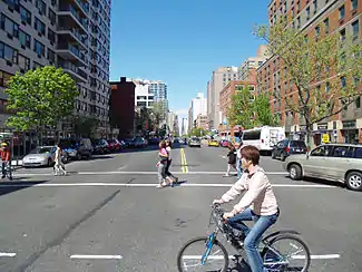
 Looking north from 9th Street in 2007 | |
| مالک | نیویورک |
|---|---|
| نگهداری توسط | سازمان ترابری نیویورک |
| طول | ۱۰٫۷ مایل[1][2] (۱۷٫۲ کیلومتر) |
| موقعیت | منهتن و برانکس، نیویورک |
| انتهای جنوبی | Astor Place / St. Mark's Place در میدان کوپر |
| تقاطعهای اصلی | Harlem River Drive در East Harlem Third Avenue Bridge در رود هارلم I-87 در Mott Haven I-95 در موریسانیا، برانکس/Tremont |
| انتهای شمالی | US 1 (Fordham Road) در Fordham |
| شرق | Second Avenue |
| غرب | خیابان پارک (مابین خیابان۸ام و ۱۴ام) Irving Place (مابین خیابانهای ۱۴ام و ۲۰ام خیابان لکسینگتون (شمال خیابان ۲۱ام) |
| ساخت | |
| ثبت رسمی | March 1811 |
این خیابان که ۱۷٫۲ کیلومتر طول دارد و از شمال به خیابان فوردهام و از جنوب به میدان کوپر محدود میشود.
نگارخانه
منابع
- Google Inc. "Third Avenue (Manhattan)". Google Maps (Map). Cartography by Google, Inc. https://goo.gl/maps/NVW2Q. Retrieved September 10, 2015.
- Google Inc. "Third Avenue (Bronx)". Google Maps (Map). Cartography by Google, Inc. https://goo.gl/maps/ghbty. Retrieved September 10, 2015.
- Nevius, Michelle & Nevius, James (2009), Inside the Apple: A Streetwise History of New York City, New York: Free Press, ISBN 141658997X
پیوند به بیرون
| در ویکیانبار پروندههایی دربارهٔ خیابان سوم موجود است. |
- Third Avenue Elevated at forgotten-ny.com
- New York Songlines: Third Avenue
This article is issued from Wikipedia. The text is licensed under Creative Commons - Attribution - Sharealike. Additional terms may apply for the media files.


.jpg.webp)
