رود تیمار
رود تیمار (تلفظ: /ˈteɪmɑːr/) رودی در کشور انگلستان است که از شهرستان کورنوال سرچشمه و به کانال مانش میریزد.
| رود تیمار (Dowr Tamar ) | |
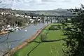
 The Tamar near Bohetherick | |
| کشور | انگلستان |
|---|---|
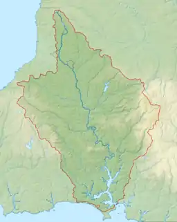
| محدوده | کورنوال، دوون |
| سرچشمه | وولی مور, Morwenstow parish |
| - موقعیت | ۵۰٫۹۲۳۵°شمالی ۴٫۴۶۲۲°غربی, کورنوال[1][2] |
| - ارتفاع | ۲۰۶ متر (۶۷۶ فوت) |
| دهانه رود | Hamoaze |
| - موقعیت | Plymouth Sound, کانال مانش |
| - مختصات | ۵۰°۲۱′۳۰″ شمالی ۴°۱۰′۰″ غربی |
| طول | ۹۸ کیلومتر (۶۱ مایل) |
| تخلیه | for Gunnislake |
| - میانگین | ۲۲٫۵۵ m3/s (۷۹۶ cu ft/s) |
| - حداکثر | ۷۱۴٫۶ m3/s (۲۵٬۲۳۶ cu ft/s) 28 December 1979 |
| - حداقل | ۰٫۵۸ m3/s (۲۰ cu ft/s) 23 August 1976 |
| Discharge elsewhere (average) | |
| - Crowford Bridge | ۲٫۳۴ m3/s (۸۳ cu ft/s) |
 Map of the Tamar catchment
| |
این رود که در شهرستانهای کورنوال و دوون جریان دارد دارای ۹۸ کیلومتر طول میباشد.
نگارخانه


منابع
- Ordnance Survey. 126 Clovelly and Hartland (Map). 1:25,000. Explorer. Section SS 260 157. http://getamap.ordnancesurvey.co.uk/getamap/frames.htm?mapAction=gaz&gazName=g&gazString=SS2693116744.
- Harding, William (16 December 1863). "Morwenstow Church". Transactions. Exeter, England: Exeter Diocesan Architectural and Archaeological Society: 218.
- Booker, Frank (1971). Industrial Archaeology of The Tamar Valley (2 ed.). Newton Abbot, England: David and Charles. ISBN 0-7153-5172-9.
- Carrington, N. T. (1820) The Banks of Tamar, a poem, with other pieces. Plymouth Dock: Printed for the Author (another ed.: London: John Murray, 1828)
پیوند به بیرون
| در ویکیانبار پروندههایی دربارهٔ رود تیمار موجود است. |
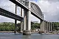
- Royal Albert Bridge at Saltash
- Tamar Crossings – Tamar Bridge & Torpoint Ferry
- RYA (tidal) Tamar navigation guide
- Tamar Valley AONB
- Tamar Valley Tourism Association
| خودمختار |
|
|---|---|
| اقامتگاههای اصلی |
|
| رودها |
|
| موضوعات |
|
| |
| خودمختار |
|
|---|---|
| بورگها و مناطق |
|
| اقامتگاههای اصلی |
|
| رودها |
|
| موضوعات |
|
This article is issued from Wikipedia. The text is licensed under Creative Commons - Attribution - Sharealike. Additional terms may apply for the media files.