سن-اییسنت، کبک
سن-اییسنت (به فرانسوی: Saint-Hyacinthe) شهرکی در منطقه شهری له ماسکوتن ناحیه مونترژی در استان کبک کانادا است. در سرشماری سال ۲۰۱۱ این شهرک ۵۱٬۹۸۴ نفر جمعیت داشتهاست و مساحت آن ۱۸۹٫۱۱ کیلومتر مربع است.[7]
Saint-Hyacinthe | |
|---|---|
City | |
 Parc Casimir-Dessaules | |
.svg.png.webp) مهر | |
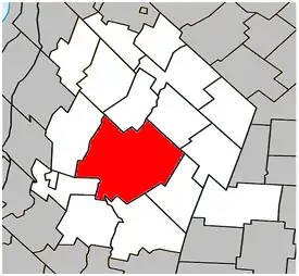 Location within Les Maskoutains Regional County Municipality. | |
 Saint-Hyacinthe موقعیت در کبک، کانادا | |
| مختصات (700, avenue de l'Hôtel-de-Ville[1]): ۴۵°۳۷′۳۳″ شمالی ۷۲°۵۶′۴۷″ غربی[2] | |
| Country | |
| استان | |
| ناحیه | مونترژی |
| منطقه شهری | له ماسکوتن |
| Founded | 1849 |
| Constituted | December 27, 2001 |
| مدیریت | |
| • شهردار | Claude Bernier |
| • Federal riding | Saint-Hyacinthe—Bagot |
| • Prov. riding | Saint-Hyacinthe |
| مساحت | |
| • City | ۱۹۱٫۶۰ کیلومتر مربع (۷۴ مایل مربع) |
| • خشکی | ۱۸۸٫۶۹ کیلومتر مربع (۷۳ مایل مربع) |
| • کلانشهری | ۳۲۶٫۷۶ کیلومتر مربع (۱۳۰ مایل مربع) |
| جمعیت | |
| • City | ۵۳٬۲۳۶ |
| • تراکم | ۲۸۲٫۱/کیلومتر مربع (۷۳۱/مایل مربع) |
| • کلانشهری | ۵۶٬۷۹۴ |
| • تراکم کلانشهری | ۱۷۳٫۸/کیلومتر مربع (۴۵۰/مایل مربع) |
| • Change (2006–11) | ▲۳٫۱% |
| • Dwellings | ۲۵۷۷۴ |
| منطقه زمانی | یوتیسی −۵ (EST) |
| • تابستان (ساعت تابستانی) | یوتیسی −۴ (EDT) |
| Postal code(s) | J2S |
| پیششماره(های) تلفن | 450 and 579 |
| Access Routes[6] A-20 / A-%route% (TCH) | Route 116 Route 137 Route 224 Route 231 Route 235 |
| وبگاه | |
جستارهای وابسته
منابع
- «Ministère des Affaires municipales, des Régions et de l'Occupation du territoire: Saint-Hyacinthe». بایگانیشده از اصلی در ۲۹ سپتامبر ۲۰۱۳. دریافتشده در ۱۹ فوریه ۲۰۱۳.
- Reference number 56749 of the Commission de toponymie du Québec (فرانسوی)
- Parliament of Canada Federal Riding History: SAINT-HYACINTHE--BAGOT (Quebec)
- 2011 Statistics Canada Census Profile: Saint-Hyacinthe, Quebec
- 2011 Statistics Canada Census Profile: Saint-Hyacinthe, Quebec (Census agglomeration). The census agglomeration consists of Saint-Hyacinthe, سن-دومینیک، کبک, سن-سیمون. In the 2006 census, the census agglomeration had not included Saint-Dominique, but had included لا پرزنتاسیون، کبک and سن-بارنابه-سود، کبک.
- «Official Transport Quebec Road Map». بایگانیشده از اصلی در ۲۴ فوریه ۲۰۱۱. دریافتشده در ۱۹ فوریه ۲۰۱۳.
- "www.mamrot.gouv.qc.ca". اداره آمار کانادا. Archived from the original on 8 October 2014. Retrieved 6 Jan 2013.
| Subdivisions |
|
|---|---|
| Communities |
|
| Major cities | |
| شهرها | |
|---|---|
| شهرداریها | |
| پریشها | |
| Villages | |
| |
Administrative divisions of Quebec |
This article is issued from Wikipedia. The text is licensed under Creative Commons - Attribution - Sharealike. Additional terms may apply for the media files.