منطقه اداری کوردیلرا
منطقه اداری کوردیلرا (به لاتین: Cordillera Administrative Region) یک منطقهٔ مسکونی در فیلیپین است که در Luzon واقع شدهاست.[2]
منطقه اداری کوردیلرا CAR | |
|---|---|
Region | |
   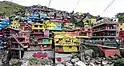  From top, left to right: Batad Rice Terraces; Tayum Church; Lubuagan, Kalinga; Colors of StoBoSa, Hanging coffins of Sagada | |
 پرچم  مهر | |
 موقعیت منطقه اداری کوردیلرا در نقشه | |
| مختصات: | |
| کشور | |
| Island group | لوزون |
| Regional center | باگیو |
| مساحت | |
| • کل | ۱۹٬۴۲۲٫۰۳ کیلومتر مربع (خطای عبارت: عملگر < دور از انتظار مایل مربع) |
| جمعیت (خطا: زمان نامعتبر سرشماری)[1] | |
| • کل | ۱٬۷۲۲٬۰۰۶ |
| • برآورد (۲۰۲۰) | ۱٬۸۰۷٬۷۵۸ |
| منطقه زمانی | یوتیسی +۸ (PST) |
| کد ایزو ۳۱۶۶ | PH-15 |
| استانهای فیلیپین | |
| Cities | ۲
|
| Municipalities | ۷۵ |
| Barangay | ۱٬۱۷۶ |
| Cong. districts | ۷ |
| Languages |
|
جستارهای وابسته
منابع
- Census of Population (2015): Total Population by Province, City, Municipality and Barangay (Report). PSA.
- مشارکتکنندگان ویکیپدیا. «Cordillera Administrative Region». در دانشنامهٔ ویکیپدیای انگلیسی.
This article is issued from Wikipedia. The text is licensed under Creative Commons - Attribution - Sharealike. Additional terms may apply for the media files.