پوپوکاتپتل
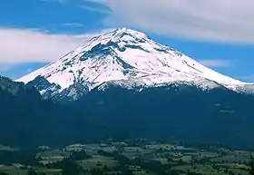
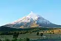
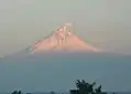
پوپوکاتپتل (انگلیسی: Popocatépetl) کوهی آتشفشانی در ایالت مورلوس، مکزیک است.
| پوپوکاتپتل | |
|---|---|
 | |
| مرتفعترین نقطه | |
| ارتفاع | ۵٬۴۲۶ متر (۱۷۸۰۲ پا) [1] |
| ایزولاسیون | ۱۴۳ کیلومتر (۸۹ مایل) |
| فهرستبندی | قله |
| جغرافیا | |
| مکان | پوئبلا-ایالت مورلوس، مکزیک |
| ایالت/استان | MX |
| زمینشناسی | |
| گونه | آتشفشان چینهای |
| آخرین فوران | ۲۰۰۵ تا ۲۰۱۴ (مداوم)[2] |
| بالا رفتن | |
| راحتترین مسیر | rock/snow climb |
ارتفاع این قله ۵٬۴۲۶ متر میباشد و و از سال ۲۰۰۵ تا ۲۰۱۴ به صورت مداوم فعال بوده است.
نگارخانه


منابع
- Sources vary widely on the elevation of Popocatépetl, with most giving a value at or slightly above 5,400 m. The 5,426 m figure given here is from the Smithsonian Institution-Global Volcanism Program.
- "Popocatépetl". Global Volcanism Program، مؤسسه اسمیتسونین. http://www.volcano.si.edu/world/volcano.cfm?vnum=1401-09=. Retrieved 2008-12-18.
This article is issued from Wikipedia. The text is licensed under Creative Commons - Attribution - Sharealike. Additional terms may apply for the media files.