کانوویندرا
کانوویندرا (به انگلیسی: Canowindra) یک شهرک در استرالیا است که در نیو ساوت ولز واقع شدهاست.[2]
| کانوویندرا نیو ساوت ولز | |||||||||
|---|---|---|---|---|---|---|---|---|---|
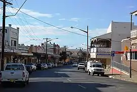
 Gaskill Street, the main street of Canowindra | |||||||||
| مختصات | ۳۳°۳۴′۰″ جنوبی ۱۴۸°۴۰′۰″ شرقی | ||||||||
| جمعیت | ۲۲۵۸ (سرشماری 2016)[1] | ||||||||
| بنیانگذاری | ۱۸۴۷ | ||||||||
| کدپستی | ۲۸۰۴ | ||||||||
| ارتفاع | ۳۰۰ متر (۹۸۴ فوت) | ||||||||
| موقعیت |
| ||||||||
| مناطق دولت محلی | Cabonne Shire | ||||||||
| حوزه انتخاباتی ایالتی | Orange | ||||||||
| Federal Division(s) | Calare | ||||||||
| |||||||||
جستارهای وابسته
منابع
- اداره آمار استرالیا (27 June 2017). "{{جا:PAGENAME}}". 2016 Census QuickStats. Retrieved 13 October 2018.

 Material was copied from this source, which is available under a Creative Commons Attribution 4.0 International License.
 - مشارکتکنندگان ویکیپدیا. «Canowindra». در دانشنامهٔ ویکیپدیای انگلیسی.
This article is issued from Wikipedia. The text is licensed under Creative Commons - Attribution - Sharealike. Additional terms may apply for the media files.