تاپلو
تاپلو (به انگلیسی: Taplow) یک روستا در بریتانیا است که در باکینگهامشر واقع شدهاست.[2]
| تاپلو | |
|---|---|
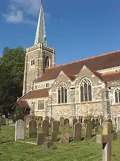 The mock-medieval parish church with green copper spire on bell tower and tall nave is listed in the initial category, built in 1911. | |
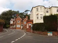 Berry Hill, part of the developed traditional core of Taplow which is mostly formal parkland with a minority of woodland and cultivated fields and hay meadows. The foot of the hill sits close to the boundary between Taplow and Maidenhead, and is situated opposite to Amerden Lane on the village's outskirts. | |
| مساحت | ۱۱٫۲۲ کیلومتر مربع (۴٫۳۳ مایل مربع) |
| جمعیت | ۱٬۶۶۹ (سرشماری ۲۰۱۱ بریتانیا)[1] |
| • تراکم جمعیت | ۱۴۹ بر کیلومتر مربع (۳۹۰ بر مایل مربع) |
| OS grid reference | SU9182 |
| محله مدنی |
|
| منطقه | |
| Shire county | |
| کشور | انگلستان |
| کشور مستقل | بریتانیا |
| پست شهر | Slough |
| کدپستی منطقه | SL6 |
| کد تلفن | ۰۱۶۲۸ |
| مجلس اروپا | جنوب شرقی انگلستان |
| مجلس انگلستان |
|
خصوصیات
تاپلو ۱۱٫۲۲ کیلومترمربع مساحت و ۱٬۶۶۹ نفر جمعیت دارد.
جستارهای وابسته
منابع
- Key Statistics: Dwellings; Quick Statistics: Population Density; Physical Environment: Land Use Survey 2005
- مشارکتکنندگان ویکیپدیا. «Taplow». در دانشنامهٔ ویکیپدیای انگلیسی، بازبینیشده در ۲۸ مارس ۲۰۱۸.
This article is issued from Wikipedia. The text is licensed under Creative Commons - Attribution - Sharealike. Additional terms may apply for the media files.