جولو، سولو
جولو، سولو (به لاتین: Jolo, Sulu) یک منطقهٔ مسکونی در فیلیپین است که در سولو واقع شدهاست.[2]
جولو، سولو Sūg / Lupah Sūg | |
|---|---|
Municipality | |
| جولو، سولو | |
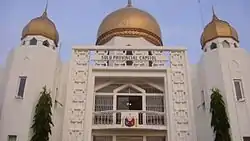 Sulu Provincial Capitol | |
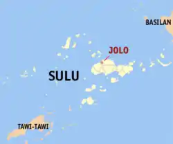 موقعیت جولو، سولو در نقشه | |
.svg.png.webp) جولو، سولو Location within the Philippines | |
| مختصات: ۰۶°۰۳′ شمالی ۱۲۱°۰۰′ شرقی | |
| کشور | فیلیپین |
| Region | سولو |
| استانهای فیلیپین | سولو |
| District | 1st district of Sulu |
| تأسیسشده | ۱۹۵۲ |
| Barangay | ۸ |
| مدیریت | |
| • شهردار | Kerkhar S. Tan (May 9. 2016) - current |
| مساحت | |
| • کل | ۱۲۶٫۴۰ کیلومتر مربع (۴۹ مایل مربع) |
| جمعیت (خطا: زمان نامعتبر سرشماری) | |
| • کل | ۱۲۵٬۵۶۴ |
| منطقه زمانی | یوتیسی +۸ (PST) |
| ZIP code | 7400 |
| Dialing code | +63 (0)68 |
| Income class | 1st municipal income class |
| PSGC | 156602000 |
| Electorate | ۵۰٬۲۷۲ voters as of خطا: زمان نامعتبر |
| وبگاه | |
خصوصیات
جولو ۱۲۶٫۴۰ کیلومترمربع مساحت دارد.
جستارهای وابسته
منابع
- "Official City/Municipal 2013 Election Results". Intramuros, Manila, Philippines: Commission on Elections (COMELEC). 1 July 2013. Retrieved 5 September 2013.
- مشارکتکنندگان ویکیپدیا. «Jolo, Sulu». در دانشنامهٔ ویکیپدیای انگلیسی، بازبینیشده در ۲۸ مارس ۲۰۱۸.
This article is issued from Wikipedia. The text is licensed under Creative Commons - Attribution - Sharealike. Additional terms may apply for the media files.