دره کاگایان
دره کاگایان (به لاتین: Cagayan Valley) یک منطقهٔ مسکونی در فیلیپین است که در Luzon واقع شدهاست.[2]
دره کاگایان Region II | |
|---|---|
Region | |
 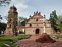 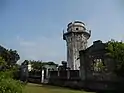 From left-to-right, top-to-bottom: Cagua Volcano; Bayombong Cathedral; Cape Engaño Lighthouse | |
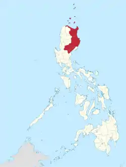 موقعیت دره کاگایان در نقشه | |
| مختصات: ۱۷°۳۷′شمالی ۱۲۱°۴۳′شرقی | |
| کشور | |
| Island group | لوزون |
| Regional center | Tuguegarao City |
| مساحت | |
| • کل | ۲۸٬۲۲۸٫۸۳ کیلومتر مربع (خطای عبارت: عملگر < دور از انتظار مایل مربع) |
| جمعیت (خطا: زمان نامعتبر سرشماری)[1] | |
| • کل | ۳٬۴۵۱٬۴۱۰ |
| • برآورد (۲۰۲۰) | ۳٬۶۵۷٬۷۴۱ |
| منطقه زمانی | یوتیسی +۸ (PST) |
| کد ایزو ۳۱۶۶ | PH-02 |
| استانهای فیلیپین | |
| Cities | ۴
|
| Municipalities | ۸۹ |
| Barangay | ۲٬۳۱۱ |
| Cong. districts | ۱۲ |
| Languages |
|
جستارهای وابسته
منابع
- Census of Population (2015): Total Population by Province, City, Municipality and Barangay (Report). PSA.
- مشارکتکنندگان ویکیپدیا. «Cagayan Valley». در دانشنامهٔ ویکیپدیای انگلیسی.
This article is issued from Wikipedia. The text is licensed under Creative Commons - Attribution - Sharealike. Additional terms may apply for the media files.