رونتا
رونتا (به انگلیسی: Rhondda) شهری در منطقهٔ منچستر-لیورپول کشور ولز است که این کشور خود بخشی از بریتانیا محسوب میشود. این شهر در سال ۱۹۹۱ میلادی ۵۹٫۹۴۷ نفر جمعیت داشته و در سرشماری سال ۲۰۰۱ جمعیت آن به ۵۹٫۶۰۲ نفر رسیدهاست. میزان رشد سالانهٔ جمعیت رونتا ۰٫۲۸ درصد میباشد و جمعیت این شهر در سال ۲۰۱۲ به ۶۱٫۴۸۰ نفر تغییر یافت.[2]
Rhondda | |
|---|---|
Valley region | |
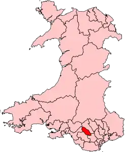 Map showing location of the Rhondda Valley within Wales | |
| مختصات: | |
| کشور | بریتانیا |
| کشور | ولز |
| شهرستان مستقل | Rhondda Cynon Taf |
| Parliamentary constituency | Rhondda |
| مساحت | |
| • کل | ۳۹ مایل مربع (۹۹٫۹۴ کیلومتر مربع) |
| بیشینه بلندی | ۱۹۳۵ پا (۵۹۰ متر) |
| جمعیت (۲۰۰۱) | |
| • کل | ۵۹٬۶۰۲ |
| منطقه زمانی | یوتیسی +۰ (ساعت گرینویچ) |
| • تابستان (ساعت تابستانی) | یوتیسی +۱ (ساعت تابستانی بریتانیا) |
| Postal code | CF postcode area |
| پیششماره(های) تلفن | ۰۱۴۴۳ |
جستارهای وابسته
منابع
- The Encyclopedia of Wales (2008) does not give the area of the Rhondda Valley, but gives the hectares for each of the 16 communities as of 2001. Clydach (487 ha), Cymmer (355 ha), Ferndale (380 ha), Llwynypia (258), Maerdy (1064 ha), Pentre (581 ha), Penygraig (481 ha), Porth (370 ha), Tonypandy (337), Trealaw (286 ha), Trehafod (164 ha), Treherbert (2156 ha), Treorchy (1330 ha), Tylorstown (590 ha), Ynyshir (441 ha), Ystrad (714 ha). Total 9994 ha
- "United Kingdom: largest cities and towns and statistics of their population". world-gazetteer. Retrieved 22 May 2012.
This article is issued from Wikipedia. The text is licensed under Creative Commons - Attribution - Sharealike. Additional terms may apply for the media files.