قلمروی خلیج جرویس
قلمروی خلیج جرویس (انگلیسی: Jervis Bay Territory) قلمروی در کشور مشترکالمنافع استرالیا است که توسط نیو ساوت ولز محصور شده است
| Jervis Bay Territory | |||||||||
|---|---|---|---|---|---|---|---|---|---|
 | |||||||||
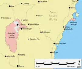 Location of the ACT and Jervis Bay | |||||||||
 Jervis Bay Territory | |||||||||
| مختصات | ۳۵°۸′۵۵″ جنوبی ۱۵۰°۴۲′۴۹″ شرقی | ||||||||
| جمعیت | ۳۷۷ (سرشماری 2011)[1] | ||||||||
| • تراکم | ۵٫۶/km2 (۱۵/sq mi) | ||||||||
| بنیانگذاری | 1915 | ||||||||
| کدپستی | 2540 | ||||||||
| مساحت | 67.8 کیلومتر مربع (۲۶٫۲ مایل مربع) [2] | ||||||||
| ناحیه زمانی | AEST (یوتیسی +10) | ||||||||
| • تابستان (DST) | AEDT (یوتیسی +11) | ||||||||
| موقعیت |
| ||||||||
| Federal Division(s) | Fenner[3] | ||||||||
| |||||||||
قلمروی خلیج جرویس ۶۷٫۸ کیلوممر مربع مساحت و ۳۷۷ نفر جمعیت دارد
این قلمرو در سال ۱۹۱۵ بنیانگذاری شده است
جستارهای وابسته
منابع
- Australian Bureau of Statistics (31 October 2012). "Jervis Bay (OT)". 2011 Census QuickStats. Retrieved 8 May 2013.
- Australian Bureau of Statistics (31 October 2012). "2011 Community Profiles: Jervis Bay (OT)". 2011 Census of Population and Housing. Retrieved 8 May 2013.
- "Profile of the electoral division of Fenner". Australian Electoral Commission. 8 February 2016. Retrieved 25 June 2016.
- "Jervis Bay (Point Perpendicular AWS)". Climate statistics for Australian locations. اداره هواشناسی استرالیا. Retrieved 8 May 2013.
- مشارکتکنندگان ویکیپدیا. «Jervis Bay Territory». در دانشنامهٔ ویکیپدیای انگلیسی، بازبینیشده در ۲۶ دسامبر ۲۰۱۴.
پیوند به بیرون
| در ویکیانبار پروندههایی دربارهٔ قلمروی خلیج جرویس موجود است. |
| خاک اصلی |  | |
|---|---|---|
| بیرون از خاک اصلی | ||
| ناحیههای پیشین |
| |
This article is issued from Wikipedia. The text is licensed under Creative Commons - Attribution - Sharealike. Additional terms may apply for the media files.