موس پس، آلاسکا
موس پس (به انگلیسی: Moose Pass) شهری در بخش شبهجزیره کنای ایالت آلاسکا است که جمعیت آن در سرشماری سال ۲۰۰۰ میلادی ۲۰۶ نفر بودهاست.[1][2]
Moose Pass, Alaska | |
|---|---|
CDP | |
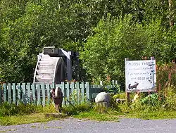 Water wheel and grindstone by side of Seward Highway. The sign reads: "Moose Pass is a peaceful little town, if you have an axe to grind, do it here." | |
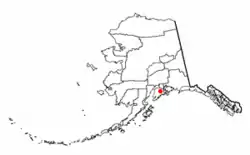 موقعیت موس پس، آلاسکا | |
| مختصات: ۶۰°۲۹′۱۶″ شمالی ۱۴۹°۲۲′۱۵″ غربی | |
| کشور | ایالات متحده آمریکا |
| ایالت | آلاسکا |
| Borough | Kenai Peninsula |
| مساحت | |
| • کل | ۱۸٫۱ مایل مربع (۴۶٫۹ کیلومتر مربع) |
| • خشکی | ۱۸٫۰ مایل مربع (۴۶٫۷ کیلومتر مربع) |
| • آب | ۰٫۱ مایل مربع (۰٫۲ کیلومتر مربع) |
| بلندی | ۴۷۲ پا (۱۴۴ متر) |
| جمعیت (۲۰۱۰) | |
| • کل | ۲۱۹ |
| • تراکم | ۱۲/مایل مربع (۴٫۷/کیلومتر مربع) |
| منطقه زمانی | یوتیسی -۹ (Alaska (AKST)) |
| • تابستان (ساعت تابستانی) | یوتیسی -۸ (AKDT) |
| زیپکد | ۹۹۶۳۱ |
| پیششماره(های) تلفن | ۹۰۷ |
| FIPS code | ۰۲–۵۰۱۹۰ |
| GNIS feature ID | ۱۴۱۷۰۷۶ |
جستارهای وابسته
منابع
- "Alaska: largest cities and towns and statistics of their population". World Gazetteer. Retrieved 19 July 2012.
- "American FactFinder". U.S. Census Bureau.
| مناطق جغرافیایی | جزایر آلیوتی • جنوب شرق • جنوب غرب • جنوب مرکز • داخله • دبوش • دره تانانا • دره مات-سو • دلتای یوکان-کاسکوکویم • آلاسکای قطبی • شبه جزیره سیوارد • شبه جزیره کنای • شیب شمالی • گذرگاه داخلی |  |
|---|---|---|
| شهرستانها | ||
| شهرها | ||
| ناحیههای سرشماری | الیوشنز غرب • الیوشنز • بتل • جنوب شرق فیربنکس • دیلینگهام • شاهزاده ویلز-هایدر • کوسیلواک • نومی • هونا-انگون • والدز کوردوا • یوکان-کویوکوک | |
| جستارهای وابسته | ||
This article is issued from Wikipedia. The text is licensed under Creative Commons - Attribution - Sharealike. Additional terms may apply for the media files.