ریزال، پالاوان
ریزال، پالاوان (به لاتین: Rizal, Palawan) یک سکونتگاه مسکونی در فیلیپین است که در پالاوان واقع شدهاست.[4]
ریزال | |
|---|---|
Municipality | |
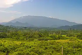 Mount Mantalingajan as seen from Ransang, Rizal | |
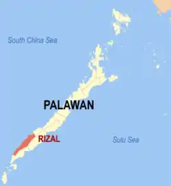 Map of Palawan with Rizal highlighted | |
.svg.png.webp) ریزال Location within the Philippines | |
| مختصات: ۰۸°۴۱′ شمالی ۱۱۷°۲۱′ شرقی | |
| کشور | فیلیپین |
| Region | MIMAROPA (Region IV-B) |
| استان | پالاوان |
| Congr. district | 2nd district |
| تاسیسشده | ۱۴ آوریل ۱۹۸۳ |
| Barangay | ۱۱ |
| مدیریت | |
| • شهردار | Nicolas T. Montano Sr. |
| مساحت | |
| • کل | ۱۲۵۶٫۴۷ کیلومتر مربع (۴۹۰ مایل مربع) |
| جمعیت (۲۰۱۰)[3] | |
| • کل | ۴۲٬۷۵۹ |
| منطقه زمانی | یوتیسی ۸+ (PST) |
| Zip Code | ۵۳۰۰ |
| Dialing code | ۴۸ |
| وبگاه | |
خصوصیات
ریزال ۱٬۲۵۶٫۴۷ کیلومترمربع مساحت و ۴۲٬۷۵۹ نفر جمعیت دارد.
جستارهای وابسته
منابع
- "Municipalities". Quezon City, Philippines: Department of the Interior and Local Government. Archived from the original on 31 May 2013. Retrieved 15 November 2012.
- "Province: PALAWAN". PSGC Interactive. Makati City, Philippines: National Statistical Coordination Board. Archived from the original on 14 November 2012. Retrieved 22 November 2012.
- "Total Population by Province, City, Municipality and Barangay: as of May 1, 2010" (PDF). 2010 Census of Population and Housing. National Statistics Office. Retrieved 22 November 2012.
- مشارکت کنندگان ویکیپدیای انگلیسی. «Rizal, Palawan».
| شهرداریها | |
|---|---|
| Highly urbanized city | (Administratively independent from the province, but grouped under Palawan by the National Statistics Office) |
This article is issued from Wikipedia. The text is licensed under Creative Commons - Attribution - Sharealike. Additional terms may apply for the media files.