سن ویسنته
سن ویسنته (به لاتین: San Vicente, Palawan) یک شهر در فیلیپین است که در پالاوان واقع شدهاست.[4]
سن ویسنته Malagnang | |
|---|---|
Municipality | |
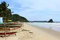
| پرونده:Port barton palawan.jpg Port Barton | |
| شعار(ها): Ang Tao Una sa Lahat, Ang Bayan Higit sa Lahat, Kaunlaran para sa Lahat | |
 Map of Palawan with San Vicente highlighted | |
.svg.png.webp) سن ویسنته Location within the Philippines | |
| مختصات: ۱۰°۳۲′ شمالی ۱۱۹°۱۷′ شرقی | |
| کشور | فیلیپین |
| Region | MIMAROPA (Region IV-B) |
| استانهای فیلیپین | پالاوان |
| Congr. district | 1st district |
| Formed | January 2, 1972 |
| Barangay | 10 |
| مدیریت | |
| • شهردار | Maria Carmela E. Alvarez |
| مساحت | |
| • کل | ۱۴۶۲٫۹۴ کیلومتر مربع (۵۶۰ مایل مربع) |
| جمعیت (2010)[3] | |
| • کل | ۳۰٬۹۱۹ |
| • تراکم | ۲۱/کیلومتر مربع (۵۵/مایل مربع) |
| منطقه زمانی | یوتیسی +۸ (PST) |
| Zip Code | 5309 |
| Dialing code | 48 |
| وبگاه | |
خصوصیات
سن ویسنته ۱٬۴۶۲٫۹۴ کیلومترمربع مساحت و ۳۰٬۹۱۹ نفر جمعیت دارد.
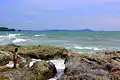
نگارخانه


جستارهای وابسته
منابع
- "Municipalities". Quezon City, Philippines: Department of the Interior and Local Government. Archived from the original on 31 May 2013. Retrieved 15 November 2012.
- "Province: PALAWAN". PSGC Interactive. Makati City, Philippines: National Statistical Coordination Board. Archived from the original on 14 November 2012. Retrieved 15 November 2012.
- "Total Population by Province, City, Municipality and Barangay: as of May 1, 2010" (PDF). 2010 Census of Population and Housing. National Statistics Office. Retrieved 15 November 2012.
- مشارکت کنندگان ویکیپدیای انگلیسی. «San Vicente, Palawan».
| شهرداریها | |
|---|---|
| Highly urbanized city | (Administratively independent from the province, but grouped under Palawan by the National Statistics Office) |
This article is issued from Wikipedia. The text is licensed under Creative Commons - Attribution - Sharealike. Additional terms may apply for the media files.