کیپ می، نیوجرسی
کیپ می (به انگلیسی: Cape May) شهری در ایالت نیوجرسی کشور ایالات متحده آمریکا است که جمعیت آن در سرشماری سال ۲۰۱۰ میلادی، ۳٬۶۰۷ نفر بودهاست.[15]
Cape May, New Jersey | |
|---|---|
City | |
| شعار(ها): The Nation's Oldest Seashore Resort | |
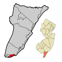 کیپ می سیتی پررنگ شده در شهرستان کیپ می. Inset map: شهرستان کیپ می پررنگ شده در ایالت نیوجرسی. | |
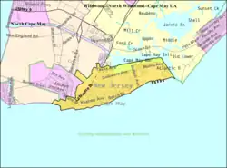 Census Bureau map of Cape May, New Jersey | |
| مختصات: ۳۸٫۹۴۰۷۸۲°شمالی ۷۴٫۹۰۳۱۹۸°غربی | |
| کشور | |
| ایالت | |
| شهرستان | کیپ می |
| Incorporated | ۸ مارس ۱۸۴۸ as Cape Island Borough |
| Reincorporated | ۱۰ مارس ۱۸۵۱ as Cape Island City |
| Reincorporated | ۹ مارس ۱۸۶۹ as Cape May City |
| مدیریت | |
| • نوع | Faulkner Act (Council-Manager) |
| • شهردار | Edward J. Mahaney, Jr. (term ended June 30, 2012)[2] |
| • Manager | Bruce A. MacLeod[3] |
| • Clerk | Louise F. Cummiskey[4] |
| مساحت | |
| • کل | ۲٫۷۴۳ مایل مربع (۷٫۱۰۳ کیلومتر مربع) |
| • خشکی | ۲٫۴۰۴ مایل مربع (۶٫۲۲۶ کیلومتر مربع) |
| • آب | ۰٫۳۳۹ مایل مربع (۰٫۸۷۷ کیلومتر مربع) 12.35% |
| رتبه مساحت | 359th of 566 in state 8th of 16 in county[5] |
| بلندی | ۱۰ پا (۳ متر) |
| جمعیت | |
| • کل | ۳٬۶۰۷ |
| • رتبه | 428th of 566 in state 8th of 16 in county[10] |
| • تراکم | ۱۵۰۰٫۶/مایل مربع (۵۷۹٫۴/کیلومتر مربع) |
| • رتبه تراکم | 336th of 566 in state 6th of 16 in county[10] |
| منطقه زمانی | یوتیسی -۵ (Eastern (EST)) |
| • تابستان (ساعت تابستانی) | یوتیسی -۴ (Eastern (EDT)) |
| زیپکد | ۰۸۲۰۴[11] |
| پیششماره(های) تلفن | 609 Exchange: 884 |
| FIPS code | ۳۴۰۰۹۱۰۲۷۰[12][5][13] |
| GNIS feature ID | ۰۸۸۵۱۷۸[14][5] |
| وبگاه | |
جستارهای وابسته
منابع
- 2005 New Jersey Legislative District Data Book, دانشگاه راتگرز Edward J. Bloustein School of Planning and Public Policy, April 2005, p. 8.
- 2012 New Jersey Mayors Directory, New Jersey Department of Community Affairs, dated August 9, 2012. Accessed October 9, 2012.
- Administration, City of Cape May. Accessed July 10, 2012.
- City Clerk and Registrar of Vital Statistics, City of Cape May. Accessed July 10, 2012.
- Gazetteer of New Jersey Places بایگانیشده در ۶ دسامبر ۲۰۱۲ توسط WebCite, اداره آمار آمریکا. Accessed October 18, 2012.
- سامانه اطلاعات نامهای جغرافیایی ایالات متحده آمریکا: City of Cape May, Geographic Names Information System. Accessed January 4, 2008.
- DP-1 - Profile of General Population and Housing Characteristics: 2010 for Cape May city, Cape May County, New Jersey, اداره آمار آمریکا. Accessed April 20, 2012.
- Municipalities Grouped by 2011-2020 Legislative Districts بایگانیشده در ۴ ژوئن ۲۰۱۹ توسط Wayback Machine, New Jersey Department of State, p. 1. Accessed January 6, 2013.
- Table DP-1. Profile of General Demographic Characteristics: 2010 for Cape May city بایگانیشده در ۳۰ آوریل ۲۰۱۲ توسط Wayback Machine, New Jersey Department of Labor and Workforce Development. Accessed April 20, 2012.
- GCT-PH1 Population, Housing Units, Area, and Density: 2010 - State -- County Subdivision from the 2010 Census Summary File 1 for New Jersey, اداره آمار آمریکا. Accessed October 9, 2012.
- Look Up a ZIP Code, خدمات پستی ایالات متحده آمریکا. Accessed November 6, 2011.
- "American FactFinder". اداره آمار آمریکا. Retrieved 2008-01-31.
- A Cure for the Common Codes: New Jersey بایگانیشده در ۲۷ مه ۲۰۱۲ توسط Archive.today, Missouri Census Data Center. Accessed July 10, 2012.
- "US Board on Geographic Names". سازمان نقشهبرداریهای زمینشناسی آمریکا. 2007-10-25. Retrieved 2008-01-31.
- "New Jersey". world-gazetteer. Retrieved 10 Jan 2013.
شهرداریها و جوامع شهرستان کیپ می، نیوجرسی، ایالات متحده | ||
|---|---|---|
| شهرها |  Map of New Jersey highlighting Cape May County | |
| Boroughs | ||
| تاونشیپها | ||
| سیدیپیها | ||
| سایر محدودههای ثبتنشده |
| |
This article is issued from Wikipedia. The text is licensed under Creative Commons - Attribution - Sharealike. Additional terms may apply for the media files.