هاوول، نیوجرسی
هاوول (به انگلیسی: Howell Township) شهری در ایالت نیوجرسی کشور ایالات متحده آمریکا است که جمعیت آن در سرشماری سال ۲۰۱۰ میلادی، ۵۱٬۰۷۵ نفر بودهاست.[19]
Howell Township, New Jersey | |
|---|---|
Township | |
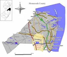
 نقشه هاوول Township در شهرستان مونموث. Inset: موقعیت شهرستان مونموث پررنگ شده در ایالت نیوجرسی. | |
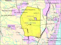
 Census Bureau map of Howell Township, New Jersey | |
| مختصات: ۴۰٫۱۸۲۰۵۱°شمالی ۷۴٫۱۹۸۵۲°غربی | |
| کشور | |
| ایالت | |
| شهرستان | مونمووث |
| Incorporated | ۲۳ فوریه ۱۸۰۱ |
| مدیریت | |
| • نوع | Faulkner Act (Council-Manager) |
| • شهردار | Bob Walsh (term ends December 31, 2012)[2] |
| • Manager | Helene Schlegel[3] |
| • Clerk | Penny A. Wollman [4] |
| مساحت | |
| • کل | ۶۱٫۲۰۹ مایل مربع (۱۵۸٫۵۳۰ کیلومتر مربع) |
| • خشکی | ۶۰٫۵۵۸ مایل مربع (۱۵۶٫۸۴۴ کیلومتر مربع) |
| • آب | ۰٫۶۵۱ مایل مربع (۱٫۶۸۶ کیلومتر مربع) 1.06% |
| رتبه مساحت | 21st of 566 in state 1st of 53 in county[5] |
| بلندی | ۸۲ پا (۲۵ متر) |
| جمعیت | |
| • کل | ۵۱٬۰۷۵ |
| • رتبه | 32nd of 566 in state 2nd of 53 in county[10] |
| • تراکم | ۸۴۳٫۴/مایل مربع (۳۲۵٫۶/کیلومتر مربع) |
| • رتبه تراکم | 402nd of 566 in state 48th of 53 in county[10] |
| منطقه زمانی | یوتیسی -۵ (Eastern (EST)) |
| • تابستان (ساعت تابستانی) | یوتیسی -۴ (Eastern (EDT)) |
| زیپکد | |
| پیششماره(های) تلفن | 732/848 و 908[15] |
| FIPS code | ۳۴۰۲۵۳۳۳۰۰[16][5][17] |
| GNIS feature ID | ۰۸۸۲۱۱۳[18][5] |
| وبگاه | |
جستارهای وابسته
منابع
- 2005 New Jersey Legislative District Data Book, دانشگاه راتگرز Edward J. Bloustein School of Planning and Public Policy, April 2005, p. 135.
- 2012 New Jersey Mayors Directory, New Jersey Department of Community Affairs, dated August 9, 2012. Accessed October 26, 2012.
- Township Manager, Howell Township. Accessed July 18, 2012.
- Clerks, Howell Township. Accessed July 18, 2012.
- Gazetteer of New Jersey Places بایگانیشده در ۶ دسامبر ۲۰۱۲ توسط WebCite, اداره آمار آمریکا. Accessed October 26, 2012.
- سامانه اطلاعات نامهای جغرافیایی ایالات متحده آمریکا: Township of Howell, Geographic Names Information System. Accessed January 4, 2008.
- DP-1 - Profile of General Population and Housing Characteristics: 2010 Demographic Profile Data for Howell township, Monmouth County, New Jersey, اداره آمار آمریکا. Accessed February 13, 2012.
- Municipalities Grouped by 2011-2020 Legislative Districts بایگانیشده در ۱۹ ژوئیه ۲۰۱۱ توسط Wayback Machine, New Jersey Department of State, p. 13. Accessed January 6, 2013.
- Table DP-1. Profile of General Demographic Characteristics: 2010 for Howell township بایگانیشده در ۱۰ سپتامبر ۲۰۱۴ توسط Wayback Machine, New Jersey Department of Labor and Workforce Development. Accessed February 13, 2012.
- GCT-PH1 Population, Housing Units, Area, and Density: 2010 - State -- County Subdivision from the 2010 Census Summary File 1 for New Jersey, اداره آمار آمریکا. Accessed December 4, 2012.
- Look Up a ZIP Code for Howell, NJ, United States Postal Service. Accessed July 18, 2012.
- Look Up a ZIP Code for Farmingdale, NJ, United States Postal Service. Accessed July 18, 2012.
- Look Up a ZIP Code for Freehold, NJ, United States Postal Service. Accessed July 18, 2012.
- Well, to begin with, Farmingdale is roughly less than one square mile, and Howell Township is sixty-four square miles, roughly. First of all, our mail, going way back, used to come out of Farmingdale Post Office and was delivered into parts of Howell Township. We had to put our address down as Farmingdale, although we did not live in Farmingdale. And today it stands. This part of Howell gets all of its mail from Farmingdale from south of the Boro boundary line with Howell to the 195 overpass now, eastward to Wall Township and westward to within a mile of Highway 9."
- Howell, New Jersey Area Code Information, AreaCodeHelp.com. Accessed August 9, 2011.
- "American FactFinder". اداره آمار آمریکا. Retrieved 2008-01-31.
- A Cure for the Common Codes: New Jersey بایگانیشده در ۲۷ مه ۲۰۱۲ توسط Archive.today, Missouri Census Data Center. Accessed July 18, 2012.
- "US Board on Geographic Names". سازمان نقشهبرداریهای زمینشناسی آمریکا. 2007-10-25. Retrieved 2008-01-31.
- "New Jersey". world-gazetteer. Retrieved 10 Jan 2013.
This article is issued from Wikipedia. The text is licensed under Creative Commons - Attribution - Sharealike. Additional terms may apply for the media files.
