وال، نیوجرسی
وال (به انگلیسی: Wall Township) شهری در ایالت نیوجرسی کشور ایالات متحده آمریکا است که جمعیت آن در سرشماری سال ۲۰۱۰ میلادی، ۲۶٬۱۶۴ نفر بودهاست.[13]
Wall Township, New Jersey | |
|---|---|
Township | |
 Map of Wall Township in Monmouth County. Inset: Location of Monmouth County highlighted in the State of New Jersey. | |
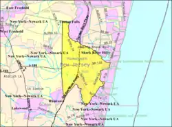 Census Bureau map of Wall Township, New Jersey | |
| مختصات: ۴۰٫۱۶۷۳°شمالی ۷۴٫۰۹۶۰۸۹°غربی | |
| کشور | United States |
| ایالات آمریکا | نیوجرسی |
| County | Monmouth |
| Incorporated | March 7, 1851 |
| مدیریت | |
| • نوع | Township |
| • شهردار | Todd W. Luttman |
| • Clerk | Lorraine Kubacz[2] |
| مساحت | |
| • کل | ۳۱٫۷۳۷ مایل مربع (۸۲٫۱۹۸ کیلومتر مربع) |
| • خشکی | ۳۰٫۶۷۳ مایل مربع (۷۹٫۴۴۳ کیلومتر مربع) |
| • آب | ۱٫۰۶۴ مایل مربع (۲٫۷۵۵ کیلومتر مربع) 3.35% |
| رتبه مساحت | 79th of 566 in state 7th of 53 in county[3] |
| بلندی | ۶۹ پا (۲۱ متر) |
| جمعیت | |
| • کل | ۲۶٬۱۶۴ |
| • رتبه | 94th of 566 in state 9th of 53 in county[8] |
| • تراکم | ۸۵۳٫۰/مایل مربع (۳۲۹٫۳/کیلومتر مربع) |
| • رتبه تراکم | 401st of 566 in state 47th of 53 in county[8] |
| منطقه زمانی | یوتیسی -۵ (EST) |
| • تابستان (ساعت تابستانی) | یوتیسی -۴ (Eastern (EDT)) |
| زیپکدs | 07719, 07727, 07731, 07753, 07762, 08724, 08736, 08750[9] |
| پیششماره(های) تلفن | 732/848 |
| FIPS code | 3402576460[10][3][11] |
| GNIS feature ID | 0882112[12][3] |
| وبگاه | |
جستارهای وابسته
منابع
- 2005 New Jersey Legislative District Data Book, دانشگاه راتگرز Edward J. Bloustein School of Planning and Public Policy, April 2005, p. 67.
- Clerk's Office بایگانیشده در ۱۰ ژانویه ۲۰۱۳ توسط Wayback Machine, Wall Township. Accessed August 9, 2012.
- Gazetteer of New Jersey Places بایگانیشده در ۶ دسامبر ۲۰۱۲ توسط WebCite, اداره آمار آمریکا. Accessed October 25, 2012.
- سامانه اطلاعات نامهای جغرافیایی ایالات متحده آمریکا: Township of Wall, Geographic Names Information System, accessed January 4, 2008.
- DP-1 - Profile of General Population and Housing Characteristics: 2010 for Wall township, Monmouth County, New Jersey, اداره آمار آمریکا. Accessed August 9, 2012.
- Municipalities Grouped by 2011-2020 Legislative Districts بایگانیشده در ۴ ژوئن ۲۰۱۹ توسط Wayback Machine, New Jersey Department of State, p. 13. Accessed January 6, 2013.
- Profile of General Demographic Characteristics: 2010 for Wall township, New Jersey Department of Labor and Workforce Development. Accessed August 9, 2012.
- GCT-PH1 Population, Housing Units, Area, and Density: 2010 - State -- County Subdivision from the 2010 Census Summary File 1 for New Jersey, اداره آمار آمریکا. Accessed September 19, 2012.
- Look Up a ZIP Code for Wall, NJ, خدمات پستی ایالات متحده آمریکا. Accessed August 9, 2012.
- "American FactFinder". اداره آمار آمریکا. Retrieved 2008-01-31.
- A Cure for the Common Codes: New Jersey بایگانیشده در ۲۷ مه ۲۰۱۲ توسط Archive.today, Missouri Census Data Center. Accessed August 9, 2012.
- "US Board on Geographic Names". سازمان نقشهبرداریهای زمینشناسی آمریکا. 2007-10-25. Retrieved 2008-01-31.
- "New Jersey". world-gazetteer. Retrieved 10 Jan 2013.
شهرداریها و جوامع شهرستان مونمووث، نیوجرسی، ایالات متحده | ||
|---|---|---|
مرکز شهرستان: Freehold Borough, New Jersey | ||
| شهرها | 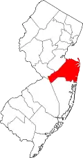 Map of New Jersey highlighting Monmouth County | |
| Boroughs |
| |
| تاونشیپها | ||
| روستاها | ||
| سیدیپیها |
| |
| سایر محدودههای ثبتنشده |
| |
This article is issued from Wikipedia. The text is licensed under Creative Commons - Attribution - Sharealike. Additional terms may apply for the media files.